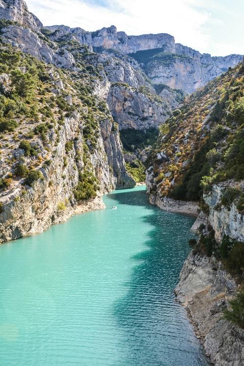
Image Credits: Grottes de Galetas © crédits Thomas Castin
The Moyen Verdon lies between the Préalpes de Digne (2,115 m) and the Préalpes de Castellane (1,996 m), from the Sainte-Croix dam to the Castillon dam. It is part of the Verdon Regional Nature Park, but the neighbouring communes of Vergons and Méailles have also been included in this trail.
This limestone area, which is ideal for carving out natural shelters and preserving bone remains, is known for its vertiginous canyon and turquoise bodies of water. The implementation of these initiatives has led to archaeological research revealing human occupation since the Lower Palaeolithic.
This area, situated at the meeting point of Mediterranean and mountain influences, is home to a rich tapestry of landscapes. From the sun-drenched ridges of the Gorges du Verdon to the narrow valley floor, and the adret to the ubac slopes, the landforms and their exposure give rise to highly contrasting combinations of vegetation: from thorny scrubland to majestic forests (beech forests). However, this vegetation is far from ancient. In the 19th century, the southern Alps and the Moyen Verdon in particular reached an alarming level of deforestation.
The vegetation cover, weakened by over-grazing, charcoal-burning and poor pedoclimatic conditions, was no longer sufficient to hold the soil, which eroded away dramatically with every storm. Laws on the restoration of mountainous terrain (RTM: promulgation 1860-1864) led (not without difficulty) to the reforestation of the Moyen Verdon watershed.